LCMS
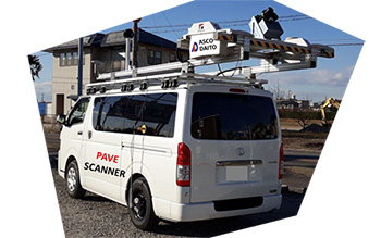
Road surface profiling system: ”PaveScanner”

This is a system equipped with MMS on the LCMS vehicle for surveying road surface property. It can acquire point clouds by laser as well as automatically analyze cracks/ruts/IRI. Since a 360-degree camera is equipped, it can also fully capture the surrounding condition. We passed the performance verification test of Civil Engineering Research Center for this system, it can provide low cost and work time shortening by automatic cracking judgment of cracks/ruts/IRI.
Features
Since this system has GNSS/IMU, it is possible to generate data with position information included. It automatically extracts the width, depth and length of cracks. The measurement width of the road surface is 4m, the transverse direction interval is 1mm, the longitudinal direction interval is 3mm, and the depth resolution is 0.5mm. Therefore it can improve the accuracy of maintenance repair plans. Pavement repair plans can be formulated by “Road Maintenance Planning System”. Laser measurement by MMS can obtain 1 million points per second.