
Ground Investigation
We survey the ground that supports people’s lives and contribute to the development of social capital and safe/secure living.
We conduct “Ground Survey” to technically examine the method of planning, designing and construction so that the ground can safely support various civil engineering/building structures, “Physical Survey” to determine the deterioration situation necessary for repair and consider the repair method, “Soil Survey” to preserve the ground environment, and “Survey necessary for grasping ground disaster situation and restoration”. We propose the best survey according to the needs of society in the social/environmental situation considering reduction in financial resources against the background of declining birthrate and aging population, deterioration of structures built during the high growth period, and heavy rains accompanying global warming and frequent earthquakes.
Services
Boring Survey
We investigate the ground structure and the continuity of the stratum with the most fundamental investigation of the ground survey. Based on the vertical supporting force, we perform in-situ tests and collect samplings for indoor soil property tests to examine compression/shear strength/consolidation/deformation property. We observe the core collected from the ground, comprehensively analyze the data obtained from various tests, and provide it as an essential ground information for design and construction of various structures and stability of the slopes.
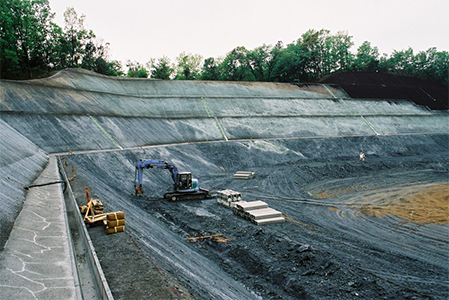
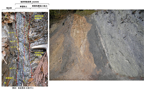
Ground Disaster Survey
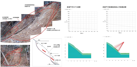
In response to ground disasters caused by heavy rain and earthquakes, we conduct dynamic observation on the slope, set up landslide block and plan for countermeasure work, predict subsidence and deformation of ground due to construction of the structure, propose countermeasure method, and consider liquefaction prediction and countermeasures. Our highly skilled geotechnical engineers conduct optimized surveys and provide analysis results.
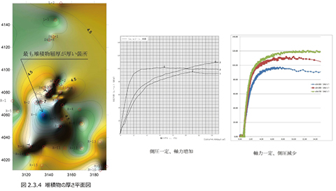
Analysis Operation
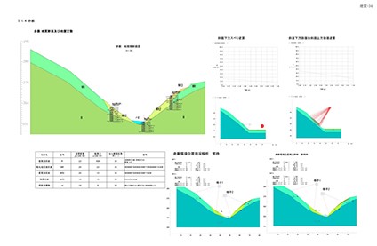
We perform “soft ground engineering analysis” for soil structures (newly/existing built) such as road banking and embankments that are built on soft ground, “ground fracture analysis/shear deformation analysis” for concerning the stability of the slope. We play an important role as an interface to inherit appropriate ground information for social infrastructure development to design and construction.
Geological Ground Survey
The geological structure in the mountainous area and the geological uniqueness are carried out in order to expand the boring data into 3D. We take a wide view of the whole survey site and examine carefully the parts that are structurally considered to be the most dangerous. We make efforts to grasp the physical property values of geology that can not be solved with only boring data.
Geophysical Survey
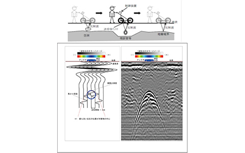
We survey artificially generated vibration, electromagnetic wave and resistivity, and indirectly analyze ground properties from the obtained physical quantity. By acquiring broad area information, it is possible to grasp a wide range of ground information at once. Although it is often carried out by a single survey method, it is also possible to simultaneously perform multiple survey methods to improve the analysis accuracy.
Groundwater Survey
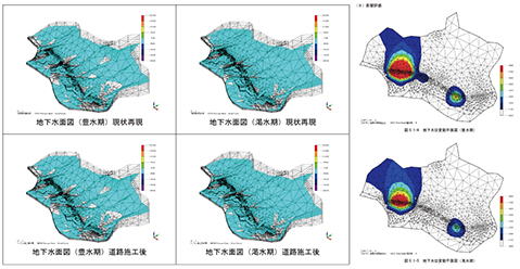
We conduct “hydrological surveys” to investigate the influence of groundwater flow change caused by the construction of the structure, and “evaluation of permeability of the ground” using single hole and “estimation of the aquifer model” by pumping test. Changes in the groundwater level are often triggers of ground disasters, therefore, the importance of underground water surveys is increasing. We analyze from various information obtained in the process from the field survey to indoor examination.
Aerial Photograph Interpretation
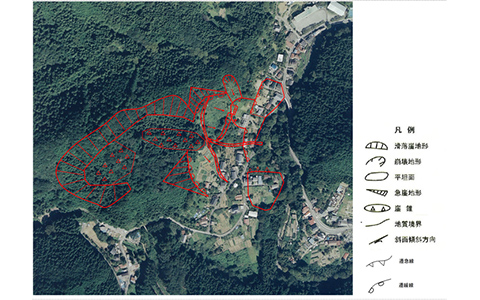
We conduct aerial photo interpretation to obtain information in advance in the initial stage of geological survey for the presence and position of abnormal terrain (linear pattern showing fault topography and landslide/collapsed terrain) and the prediction of the regional geological condition. It is essential to analyze the results of geological reconnaissance and the interpretation of boring data, as this allows us to set appropriate physical property values.
